Contents
Index
Add Control
The add function allows you to create a new control point.
Point Number
Click on the point to which the control should be attached, or type in the point number.
The current coordinates of the point will then be displayed
Name
Enter the Name of the Control Point.
If the “Master File” option is to be used, be careful that the name of each control point is
exactly the same as its name in the Control Point Master File.
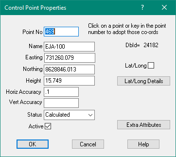
Easting
Every point must have an Easting (X) value, and it must be on the same datum and zone as
the other control points in the job.
Northing
Every point must have a Northing (Y) value, and it must be on the same datum and zone as
the other control points in the job.
Height
The height (Z) value for the point is optional.
If a point has no height value, this field will be blank.
The adjustment uses the value of the nearest control point to compute the height
above sea level correction for parcel lines.
If there are no control point heights, it is assumed that this correction need not apply
Horizontal Accuracy
The horizontal accuracy field is not used by the adjustment at this stage as all active
control points are assumed to be fixed points.
Vertical Accuracy
The vertical accuracy field is not used by the adjustment at this stage as all active
control points are assumed to be fixed points.
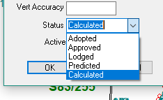
Status
The status value show the technical control point status as follows.
- Adopted - The coordinates of the mark have been adjusted as part of a larger geodetic network adjustment that connects
to datum (nominal +/- 30mm horizontal positional uncertainty)
- Approved - The coordinates of the mark have been submitted to and, and validated by the custodian via a local geodetic
network adjustment (nominal +/- 30mm horizontal survey uncertainty)
- Lodged - The mark exists but no surveyed position has been established.
- Predicted - Coordinates are derived from Cadastral adjustment within SPICAD.
The point may be on a Survey plan but has no geodetic co-ordinates available.
Should never be made active in Cadastral adjustment.
- Calculated - Coordinates are calculated from cadastral data or defined by latitude, longitude.
The point may be on a Survey plan but has no geodetic co-ordinates available.
The hierarchy of the marks that can be held active in an adjustment are:
1. Adopted
2. Approved
3. Calculated
Predicted or Lodged marks should never be held active as their values have come about from a SPICAD adjustment itself.